AI Tools for Real Estate Developers in Site Selection
AI automates site screening faster than developers can evaluate other real estate decisions.

AI real estate stories usually linger on brokerage tools: CRMs that compose follow-up notes, instant listing copy, and lead scores that set the buyer callback order. Those tools do not address the real challenge for institutional developers. Site selection was the first real estate development task to carry AI out of trials and into daily operations, because the job itself made that shift practical. Acquisitions, design, construction, and operations have each run trials at different points in development, yet site screening is the discipline with a settled workflow already in production, not parked in a presentation under "innovation roadmap." Seeing why it led, and why it advanced fastest, helps developers decide where the next technology budget should go.
It comes down less to the cleverness of the tools than to the inputs they started from. Zoning records, demographic datasets, and parcel data had been public and machine-readable for years, waiting for any AI tool to come along and exploit them. Rental comps lived in proprietary, subscription-based databases, reachable yet dispersed. In other words, everything a solid site screen needed was already on hand, in structured form. It still needed a fast unifying layer, the kind of synthesis work that modern AI tools are built to handle. Design and construction workflows are messier on the ground and much less consistently digitized, leaving AI with thinner material to use. Site selection gave it a head start.
What AI really fixed was a problem of scale when time was short. Done the old way, a proper review of one site could cost an analyst several days. A developer covering many jurisdictions at the same time, as active deal sourcing typically requires, could not stretch that effort by ten or twenty and expect nothing to slip through. Overlay rules slip past. As timelines tighten, teams have less room to investigate every angle. Teams end up choosing from an incomplete picture because the workload exceeds the time available, not because people fail to take proper care. The gap lies in the process rather than the people, and today’s site selection tools were designed to fix it.
What the old site selection process cost developers
The workflow dragged, and its real weakness showed when teams tried to scale it. A run usually unfolded in fragments: broker listings arrived first, then an analyst checked zoning and parcel records across multiple tabs, county files were pulled one by one, the spreadsheet was manually revised, and a consultant was asked to clear up what the public record left uncertain. Along the way, a detail would slip through. The process was too fragmented, with no single view that brought everything into focus.
Teams worked hard inside this system, yet sheer exertion was never the fundamental issue. Information was scattered across dozens of unlinked locations, including assessor portals at the county level, municipal GIS hubs, proprietary comp archives, and distinct zoning code repositories. The process built to pull from all of them could only handle a few sites at once. Adding another market, jurisdiction, or zoning authority with unique rules multiplied the hours required rather than increasing them proportionally. It compounded.
That meant two risks stacked up. First, fatal constraints, from overlooked zoning layers to hazards sitting in county files to off-site service needs costing six figures, often came to light only after closing, once a clean exit was no longer available. Second, teams often waited to test feasibility seriously until the letter of intent was already signed. By then, the developer is already invested financially and reputationally, making it harder to judge the opportunity on exit signals instead of momentum to proceed.
The issue became most acute for teams building data centers and industrial facilities. In those sectors, available power now decides whether a site stays in contention, before teams weigh zoning, price, or almost any other factor. A manual review means pulling utility reserve-margin filings, monitoring where projects sit in interconnection queues, and mapping nearby substations for each potential site in each relevant utility territory simultaneously. A single site can still be checked manually. Reviewing a quarterly pipeline of fifteen data center sites, however, is nearly impossible without an automated data feed.
How AI reorganizes the screening pipeline from end to end
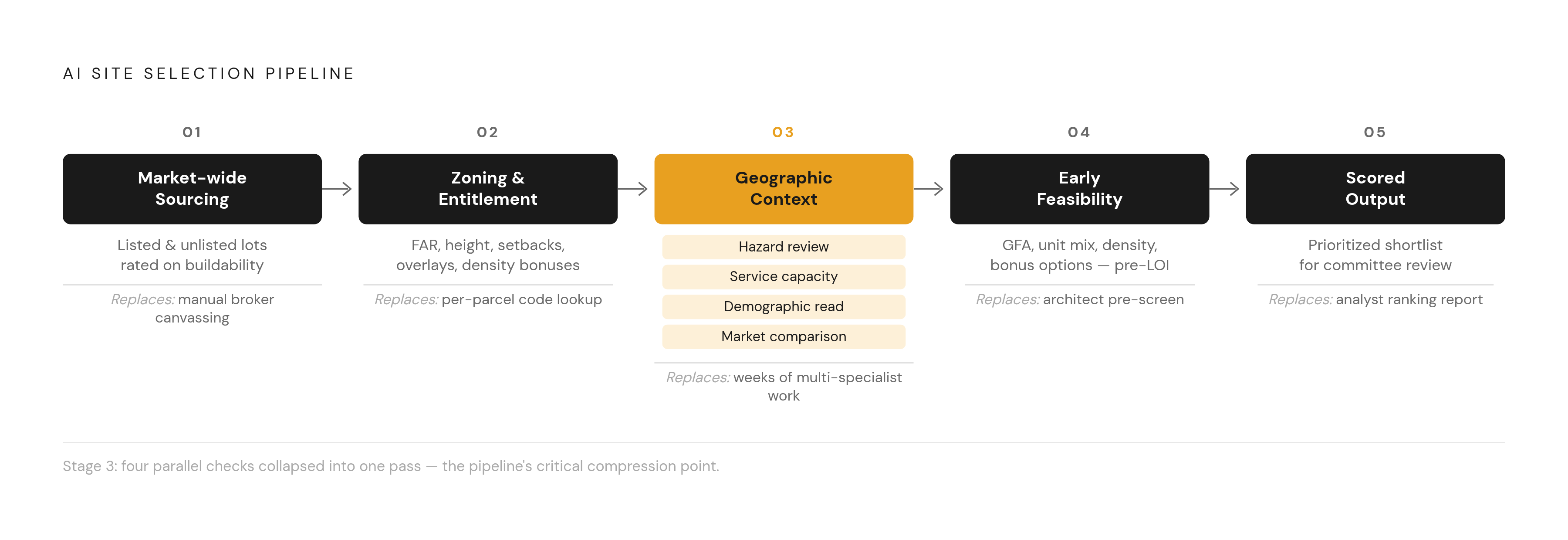
AI does not change just one step in this process. It changes the order of the work. A structured workflow now brings in geospatial inputs, adds utility and zoning layers, applies a criteria matrix to rank each potential site, and sends the best options to people for review, shrinking weeks of work into hours. Even the largest analyst team could not examine so many sites in parallel at that level of detail. This workflow unfolds in five stages, with each stage taking over a defined task from the former manual slog.
Market-wide sourcing forms the initial phase. AI tools examine every available property rather than restricting searches to active listings, because prime development targets tend to be places nobody is advertising: underused lots, sellers open to the right proposal, and parcels whose price ignores their true buildable capacity. Because filters limited to public listings overlook the most promising locations, these systems reveal unlisted properties together with those already advertised.
During the second stage, zoning and entitlement screening, these platforms separate themselves from a simple zoning lookup. The response must target the individual lot rather than summarizing general district permissions. This requires extracting allowed uses, floor-area limits, height caps, setback rules, overlay restrictions, and density incentives specific to that site, tracing each number back to its originating municipal source. Anyone reviewing those results needs a direct link to the specific ordinance or municipal code section supporting every figure.
The third stage brings geographic context into the review by handling four checks in parallel, work that previously required four specialist calls. The hazard review flags flood exposure, earthquake and fire risk, contaminated soils, and environmental constraints early enough to avoid the issue that most often stalls deals. It also gauges service capacity for the site across plumbing, wastewater, and power connections, while noting nearby road and transit plans. The demographic read looks at who is moving in, how incomes and jobs are shifting, and how easily people can get around on foot. The market comparison view reviews planned supply, absorption, rent movement, and rival developments nearby. The time savings come from packaging the four reviews into one pass instead of parceling the research across multiple people over multiple weeks.
The fourth stage handles early feasibility work during screening, before anyone signs a letter of intent rather than after. In practice, the team tests the likely building area, potential unit mixes, allowable density, and relevant bonus options before narrowing the field to one site. Spotting upside or a deal-killing limit then keeps the discovery ahead of any financial commitment or reputational stake.
Output forms the fifth stage, delivering developers a prioritized, scored list tailored for committee evaluation rather than an unfiltered dump of all system findings. That changes what the developer does. Instead of building the assessment from nothing, the role shifts to confirming preexisting conclusions, saving both mental effort and administrative time. Scrutinizing a ranked shortlist demands another sort of focus than assembling one from scratch, enabling leaner crews to handle far more transactions.
The tools developers are running in this pipeline
No platform covers each stage of this pipeline with the same strength, so the tools people run specialize by stage instead of going head-to-head through all of them.
ArchiWise provides two connected tools to handle initial property discovery and lot evaluation. The AI Site Selection module scans both public listings and unlisted properties, rating every lot on its buildability to eliminate the blind spots of traditional prospecting. The AI Zoning Expert supplies lot-specific details on allowed uses, FAR, height limits, required yard depths, special district layers, plus density bonuses. Because local ordinances change frequently, the platform refreshes its underlying records each day and traces every number back to authoritative government databases.
At the analysis stage for geospatial work, tools built on ArcGIS combine mapping data and imagery with market and demographic layers, letting developers visualize hazard zones, growth patterns, and infrastructure in one place instead of separate files.
When evaluating markets and submarkets, CoStar embeds AI-driven analysis examining local supply pipelines alongside absorption trends and comparable rent growth so developers can identify the product type best positioned to achieve their desired financial outcomes locally. Reonomy occupies a similar space yet serves another purpose, targeting off-market transactions and owner discovery rather than evaluating returns at the submarket level, which is how developers apply it.
A newer version uses a fully agentic stack, with a developer pairing tools such as Claude Cowork and Claude Code with parcel and zoning sources including Regrid, ATTOM, Realie, ArcGIS or Mapbox location layers, hazard data, plus a development modeling skill layered above. In this configuration, the platform can screen sites end to end with much less human effort between steps, without someone manually shuttling outputs across assisted tools. Adoption is now more practical because Green Street, Yardi Matrix, and MSCI Real Assets are among the commercial real estate data firms offering MCP servers, so licensed feeds can be wired straight into agentic workflows without manual file exports and imports.
What separates a tool that holds up in committee from one that creates liability
When reviewing any site selection tool, the key test is whether each output points to the source behind it. A score no one can walk through will not hold up before the development committee or later in diligence when outside capital enters the picture. Every metric the tool reports, from FAR to hazard exposure, needs to identify the precise source record. Without a direct link to its official municipal source, the committee should not rely on that number.
The market is splitting in two. Some tools are black boxes: quicker to ship, since their developers can keep the scoring logic hidden, but much tougher to justify when the committee presses them on how a site earned its score. Others are glass boxes, laying out each input behind a score and its origin. For teams that have to defend their numbers in committee, that difference has become a real differentiator.
The real liability in black-box scoring comes from how these models work. AI can pick up signals from past data, while real estate markets rarely follow a straight path. A recession, a rate shock, a new rule, or an unforeseen event can each break the market assumptions a model learned from. When a tool hides its logic, a bad forecast leaves no audit trail, and the developer who trusted it cannot reconstruct the blind spot or its cause.
A further layer of danger comes from biased algorithms. Models trained on prejudiced historical records may yield skewed outcomes when evaluating applicants or appraising real estate. Builders of housing face genuine liability under the Fair Housing Act, moving the issue beyond theory. Preventing such bias demands continuous oversight and careful dataset management throughout the entire lifecycle rather than a single initial review.
The presentation of results carries nearly equal weight to the analytical method itself. Documents reaching a committee should appear polished, easily distributed, and self-contained with complete references, requiring no intermediary to convert unrefined figures into a presentable format.
Where AI still stops and human judgment still leads
The aforementioned pipeline terminates, yielding to informal exchanges between people. A deal's gravest dangers lie past that boundary, outside the realm of zoning overlays and parcel data.
Community sentiment falls outside AI's judgment. No algorithm can gauge the mood in a planning commission session or predict how heated an entitlement dispute might become ahead of any scheduled public hearing. Those judgments remain the developer's alone, as nothing in the analytical process outlined earlier touches them.
AI remains weakest when applied to approvals and entitlements across a project’s path. AI tools can help teams check zoning rules, interpret overlay requirements, and spot variance issues that could affect a site. Still, those outputs do not address the local politics involved in approvals: resident pushback, relationships with individual council members, or bargaining over community benefits. Success there depends on practitioners who know the place and carry credibility with the decision-makers.
In the end, fieldwork hinges on judgment only a flesh-and-blood site selector supplies: dialing a number, talking it through, and deciding by how a voice sounds, where it falters, and what goes unsaid. AI can't gauge whether a community truly welcomes business, nor can it face a zoning board or neighborhood group in person and clear away an obstacle that might otherwise doom a project. Negotiating like this rests on personal connections and a feel for the room that no dataset can record.
Teams getting the greatest return from AI redesigned their process around this boundary. They use AI to sort heavy information loads, identify recurring signals, and pull details from documents, the work it is actually good at, while keeping experienced judgment at each point where those abilities are not enough. AI support makes research less cumbersome and brings risks to light earlier than manual review did, yet each ultimate decision still needs confirmation from the appropriate city departments and licensed experts, including planners, architects, engineering consultants, builders, legal counsel, land survey professionals, and finance advisers. The real advantage comes from placing that handoff correctly, neither rejecting AI wholesale nor relying on it too far, so developers gain speed without simply accelerating costly errors.